
SRTM: Shuttle Radar Topography Mission
B.J. Guillot
GEOL6325
February 11, 2004

|
SRTM: Shuttle Radar Topography Mission
B.J. Guillot
| |
1. Sensor names
SRTM obtained elevation data on a near-global scale to generate the most complete high-resolution digital topographic database of Earth.
C-Band sensor: SIR-C (Spacebourne Imaging Radar-C)
X-Band sensor: X-SAR (X-Band Synthetic Aperature Radar)
2. Satellite name or airplane type
NASA Space Shuttle Endeavour Mission STS-99
Launch: February 11, 2000
Landing: February 22, 2000
181 orbits, 11 days 5 hours 39 minutes 41 second duration
3. Country of origin
USA (NASA) collaboration with Department of Defense's National Imagery and Mapping Agency (NIMA), the German Aerospace Center (DLR) and Italian Space Agency (ASI).
4. Parts of the spectrum sensed (visible, microwave, etc.)
C-Band and X-Band are in the microwave portion of the electromagnetic spectrum.
5. Operational altitude
Orbit: 126 nautical miles @ 57 degree inclination
Maps topography from 60N-56S latitude (80% of Earth landmass)
6. Sensor type
Radar interferometry (60m fixed-baseline)
Main antenna: Transmit and Receive C-Band and X-Band Radar
Outboard antenna: Receive only C-Band and X-Band Radar
7. Number of image bands
Two bands (C-Band and X-Band) used to generate DEMs (Digital Elevation Maps).
8. Spectral ranges (in microns, cm, or nm)
C-Band: 5.6 cm
X-Band: 3 cm
9. Spatial resolutions
Absolute vertical accuracy: 16m
Absolute horizontal accuracy: 20m
Data points spaced every 1 arcsecond of latitude and longitude (approximately 30m).
The 30m spatial resolution matches that of most Landsat images and the Landsat image can be draped over the DEM (Digital Elevation Map) created from the SRTM radar data allowing for true-color (or infrared) 3D data visualization of the Earth's surface.30m resolution data is publicly available for the United States. The rest of the world will have 90m resolution, but 30m resolution can be requested on a case-by-case basis.
10. Swath width
C-band: 225 km (140 miles)
X-band: 50 km (higher resolution than the C-band images)
11. Repeat cycle (sat only)
Because the SRTM mission lasted only 11 days, most areas were mapped only one or twice.
Land coverage: Targetted land was 80% of Earth landmass (119.56 M km2, 46.16 M mi2)
99.968% targetted land mapped at least once (119.51 M km2, 46.14 M mi2)Land area missed: 50,000 km2 (all in US)
94.59% targetted land mapped at least twice (113.10 M km2, 43.66 M mi2)
49.25% targetted land mapped at least 3 times (58.59 M km2, 22.73 M mi2)
24.10% targetted land mapped at least 4 times (28.81 M km2, 11.12 M mi2)
12. Base of operations (airplane only)
Shuttle launched from and landed at Kennedy Space Center in Florida.
13. Years of data availability
Mapping begins: STS-99 Flight Day 2 February 12, 2000
Mapping ends: STS-99 Flight Day 11 February 21, 2000
14. Two or more internet sites for information (including how to obtain data)
C-band data: http://edc.usgs.gov/srtm/data/obtainingdata.html (ENGLISH)
X-band data: http://www.caf.dlr.de/caf/institut/dfd/ (GERMAN)
X-band data: http://www.dlr.de/srtm(GERMAN)
X-band data: http://srtm.die.unifi.it/(ITALIAN)
15. Internet site that shows a good sample of an image
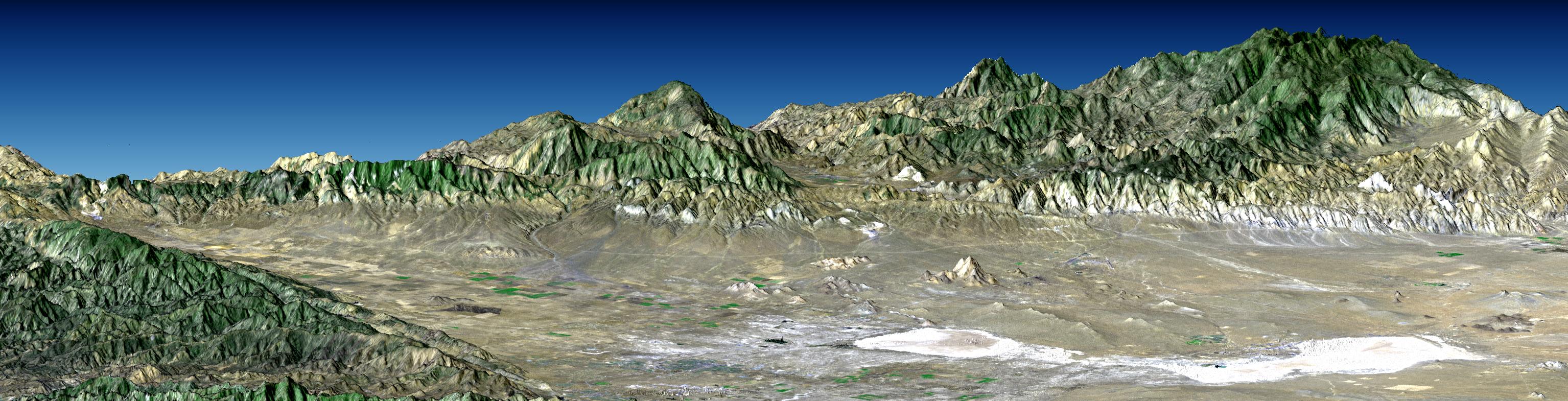
Perspective with Landsat Overlay: Antelope Valley, California

Shaded relief, color as height, Salalah, Oman
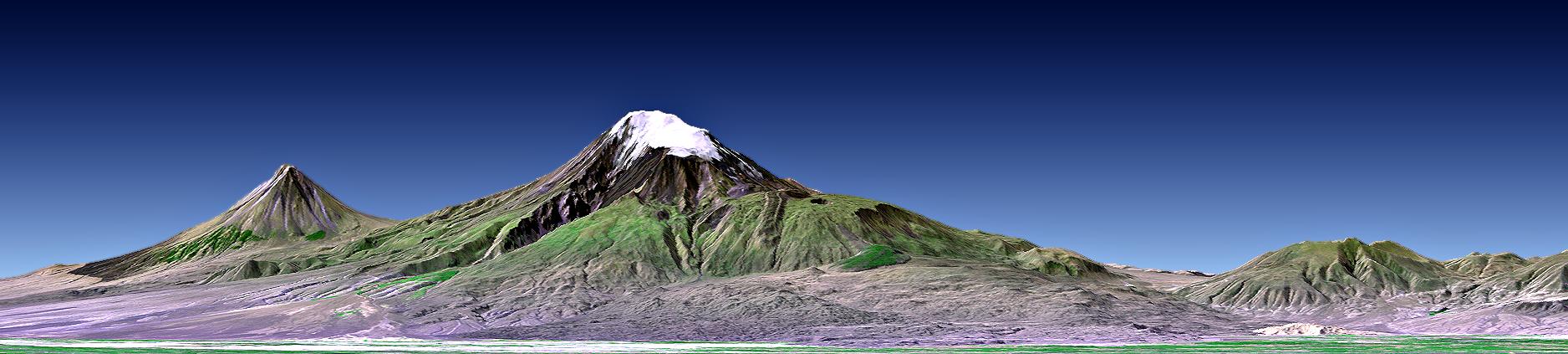
Mount Ararat, Turkey, Perspective with Landsat Image Overlay
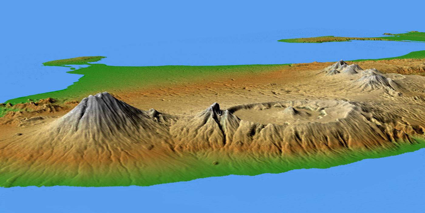
Mts. Agung and Batur, Bali, Shaded Relief and Colored Height
16. Prices of imagery
C-Band data is available for free download of up to 30 degrees square area
30 sq deg = 1.6 GB of data, downloadable as 100 MB chunks
CD-ROM can be purchased for $32/CD + $45 processing + $5 shipping
Each CD-ROM can hold 600 MB.
17. Imagery available on what type of media (CD, etc.)
C-band North America and South America datasets are available to the public.
The complete C-band public data set will be available in mid-2004.
C-Band data can be downloaded for free or purchased on CD-ROM (see #16).
Data formats available: ArcGrid, BIL (integer data), and TIFF (32 bit floating point grid).
18. Radiometric resolution of data (might be hard to find in some cases)
Unknown.
19. Other useful information for a researcher using this data
SRTM Mission StatisticsThe predecessor to the SRTM is the SIR-C and X-SAR instruments which flew twice on the space shuttle in 1994. The instrument was modified and launched in 2000 on the SRTM mission. The 1994 missions included an L-band antenna that was not used in the SRTM mission. The 1994 missions tested repeat-pass interferometry (which include much larger baselines than the 60m fixed-baseline of the SRTM mission.)
The two previous flights:STS-59 April 9-20, 1994
STS-68 September 30-October 11, 1994


